The International Charter: Space and Major Disasters, better known as the Disaster Charter, was formed on 20 October 2000 by the European Space Agency (ESA), French Space Agency (CNES) and the Canadian Space Agency (CSA), with the UK joining in 2005. The goal is to provide free data from satellites to aid disaster response around the world.
20 years on, the Charter has 17 members and 61 contributing satellites, supporting people in need in 126 countries. In total the Charter has been activated over 670 times – at no cost to those who need it.
What is the Disaster Charter?
The Disaster Charter is a worldwide collaboration, making satellite data available to help with disaster management.
It helps us respond to major natural and human-made disasters, with the aim of saving lives and livelihoods. Information derived from satellite data sourced via the Charter assists the coordination of resources and expertise for rapid response in major disaster situations, helping civil protection authorities and the international humanitarian community.
The Charter can be activated by authorised users from 126 countries and the UN as a cooperating body. All countries can ask an authorised country to activate it on their behalf, meaning the Charter can be used by any country in need, anywhere in the world. Any country can also apply to become an authorised user under the Charters universal access initiative.
What impact has the Charter had?
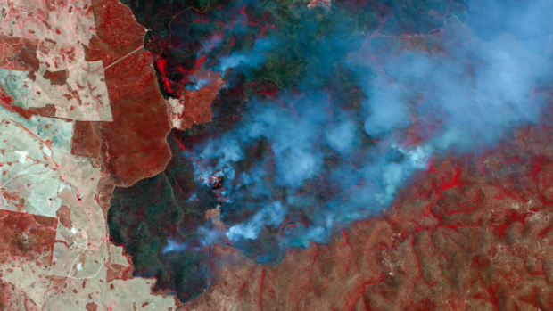
On average, the Charter is activated weekly, covering disasters from earthquakes and volcanoes to oil spills. In August this year, the Disaster Charter was activated following the devastating industrial explosion in Beirut, Lebanon. Satellite images of the region helped determine the level of damage and aided the search for safe routes for rescue teams. The Charter was also called upon during the Australian wildfires earlier this year when over a million hectares were alight, helping over 3000 firefighters pinpoint where assistance was needed most.

What happens when disaster strikes?
When a disaster strikes, an Authorised User (AU) activates the Charter, kick-starting an international effort. In some cases, co-operating bodies and organisations may request further data. Next, an On-Duty Operator, who is available 24 hours a day, verifies the activation and forwards it to an Emergency On-Call Officer (ECO). The ECO then prepares by identifying available satellites and which of those would be the best ones to use based on the disaster type and circumstances. This plan is submitted to the relevant satellite operators, who task their satellites accordingly.
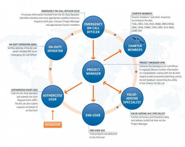
Then, a Project Manager (PM), an expert in data handling, is assigned by the Executive Secretariat to assist the AU. The PM coordinates the delivery of maps from the Value Added Providers - they take the data provided by member agencies and interpret this, assessing what they see from the satellites; for example, in a flood they can monitor and track the change in flood extent and water levels. Finally, these maps are then given to the end-user to plan their disaster management and relief efforts.
Disaster Charter and the UK
Since 2005 the UK has contributed satellite imagery and operations to the Charter through the DMC Constellation, operated by Airbus Defence and Space Limited. The UK team at Airbus performs ECO duties and jumps into action to task these UK missions whenever required.
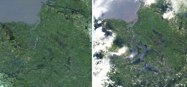
The UK has activated the Charter on multiple occasions, the last time in 2014 when major floods hit the south of England, necessitating the evacuation of more than 400 homes. The satellite imagery of the area assisted the Environment Agency in determining flood extent and the height of the water levels over large areas, resulting in the issuing of relevant warnings as well as planning and preparation for any rescues.
Various projects funded through the UK Space Agency’s International Partnership Programme (IPP) – all of which develop space-based solutions to help developing countries – have supported Disaster Charter work. These include rapid processing of satellite images of South Pacific islands to map damage to critical infrastructure caused by Cyclone Harold (CommonSensing), and using satellite communications tools to trace people following disasters in the Philippines (Inmarsat).
The Disaster Charter is an invaluable international tool that frequently provides lifesaving information and data. So spread the word and be assured that, when the next disaster hits, there are globally connected teams working together and using satellites to save lives.
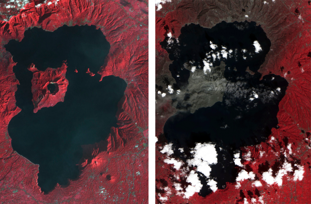
Post-Eruption, Taal, Philippines, Charter Call 639. Credit: DMC Constellation, KazSTSAT image © Ghalam LLP, Distribution Airbus Defence and Space Limited 2020
Leave a comment